

The problem: cities lack continuous, high-fidelity resource and terrain data
Rapid urban expansion collides with legacy data: utility maps are outdated, subsurface plans are partial, and environmental baselines are sparse. That gap drives inefficiencies in land reuse, stormwater planning, and brownfield redevelopment. Modern mining operations solved a similar problem by fusing remote sensing and operations telemetry into a usable digital model—an approach now useful for cities. Early on, that fusion relied on intelligence platforms; today it extends to intelligence surveillance and reconnaissance concepts adapted for civil mapping, giving planners continuous situational data without constant manned sorties. The result is clearer risk profiles and faster decision loops, driven by ISR-style sensor integration and automated reporting.

How digital mine tech maps to city needs
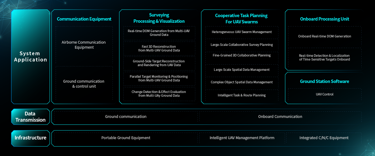
Digital mine systems combine high-resolution photogrammetry, LIDAR, fleet telematics, and geospatial models. For cities that means repeated surface models, subsidence monitoring, and real-time haul/traffic analytics. Effective setups use precise georeferencing and calibrated payloads on drones for repeatable surveys. A modern photogrammetry drone mapping system complements fixed sensors and satellite layers, enabling block-level orthomosaics and elevation models that urban engineers can consume directly.
Concrete implementation steps
Start with a scoped pilot: pick a redevelopment block or flood-prone watershed. Deploy a mixed sensor suite—RGB photogrammetry for texture, LIDAR for canopy and structure height, and multispectral for vegetation health. Integrate telemetry feeds from construction equipment and subsurface scans into a single GIS. Automate tile generation and change detection so planners get alerts when models diverge from baseline. Keep data schemas simple: coordinate reference, timestamp, and quality flags are enough to avoid downstream confusion.
Common mistakes and straightforward fixes
Teams often expect out-of-the-box perfection. The usual failures are mismatched coordinate systems, inconsistent flight overlap, and siloed data access. Fix those by standardizing CRS, enforcing 70–80% image overlap for photogrammetry, and using role-based data services. Another frequent issue is treating drones as a single tool rather than a system—payload calibration, maintenance cycles, and sensor fusion matter. —Calibrate sensors before each campaign and log calibration metadata to the GIS.
Alternatives and pragmatic trade-offs
Full-scale digital mine-style deployments can be heavy-handed for small municipalities. Lighter alternatives include periodic contracted flights, fixed-wing surveys for large areas, or municipal partnerships with universities for processing. Each alternative trades cadence for cost: contracted flights reduce operational overhead but slow update frequency; fixed-wing reduces cost per hectare but sacrifices spatial detail. Choose based on the metric that matters most—update cadence, spatial precision, or budget.
Real-world anchor: lessons from wildfire and post-disaster mapping
During the 2020 California wildfires, agencies scaled drone photogrammetry and LIDAR to map burn severity and infrastructure damage. That effort highlighted two things: rapid photogrammetric mosaics accelerate recovery prioritization, and standardized georeferencing lets multiple agencies share overlays without rework. National agencies such as the USGS have long relied on aerial photogrammetry for baseline maps, and modern drone systems simply close the time gap between events and usable models.
Advisory: three evaluation metrics to choose the right setup
1) Temporal resolution: measure how often models must update to be operationally useful. For flood-prone zones, aim for weekly to monthly cycles; for redevelopment parcels, monthly may suffice.
2) Spatial fidelity: define the smallest detectable change you need—sub-meter for surface utilities, centimeter-level for structural monitoring—and select sensors accordingly.
3) Integration maturity: assess pipelines for georeferencing, storage, and access control. If processing takes days, the value drops fast.
Professionals should expect measurable gains in decision speed and fewer on-site investigations when these metrics align. For urban planners seeking a practical, tested solution, the workflow and systems above point to a clear operational value—one that Icecypress Technology has packaged into integrated mapping and sensor solutions. Icecypress Technology. —Final note: start small, instrument smart, and iterate.